
How the DeWitts Corners Spinel Pits were Lost and Found Again
This detailed article presents a fascinating deep dive in history and minerals for a famous local location.
Give us feedback below.

Finest Spinel Crystals on Canada
The spinel occurrence known as the DeWitts Corners locality southwest of Perth, Ontario is the source of some of the finest spinel crystals in Canada as well as the rare mineral magnesiohögbomite and impressive corundum pseudomorphs after spinel. It also has a long history of being found and then lost again which is outlined in this article, followed by a detailed description of the minerals from this fascinating locality.
Original DeWitts Corner
The DeWitts Corners site was originally developed, pre-1847, to mine calcite from two adjacent shallow pits on a salmon-orange-pink calcite vein-dike as feed to a nearby small lime kiln on the farm of a Mr. Ritchie. This burning of the calcite is the reason that there are currently no tailings dumps of calcite from either of the pits. In fact there are no external dumps whatsoever around either pit, which renders them essentially invisible even at close range. The spinel formed clinkers in the burnt lime and rendered it of little value so the pits were rapidly abandoned when they were some three and six feet in depth. The Mindat.org location is given as lots 10 and 11 of concession 1, Bathurst Township. These two adjacent lots are separated by the Menzies Munro sideroad and contain two separate spinel occurrences.
Limestone and Hornblende
The lot 10 locality is in a band of white crystalline limestone, running northeast-southwest, that contains many crystals of black hornblende with minor, but occasionally large, spinel crystals that are partly to completely pseudomorphically replaced by microcrystalline grey-green corundum; there are excellent examples of these replacements in the Canadian Museum of Nature collection. The marble band lies in the bed of the Tay River, runs under the bridge on the Menzies Munro sideroad, and was the source of the corundum pseudomorphs which were originally found locally distributed along the north bank of the river to the west of the sideroad. Unfortunately, this locality is currently inaccessible due to the presence of a recent large beaver dam downstream.
Calcite and Spinel
Lot 11 is the location of the two pits on the salmon-colour calcite vein dike (Joyce, 2006) from which the best spinel crystals have been recovered (G.W. Robinson, pers. comm. 2019). The reason that mineral collections have consistently labelled all specimens as coming from lot 10 is unknown but is probably because the lime kiln was located in lot 10 and that lot had the easiest access from Perth, via the “Scotch Line”, in the 1840’s.

Fine Crystal Finds
The first published reference to this locality was by the mineralogist of the Geological Survey of Canada, Dr. T. Sterry Hunt in 1848 (Hunt, 1848). He was searching for the source of specimens that he had observed in the collection of Dr. James Wilson of Perth. Dr. Wilson was a physician and a keen amateur mineral collector after whom Hunt would later name wilsonite for the muscovite-after-scapolite pseudomorphs from the Kent Apatite Mine in Bathurst Township (Horváth, 2003). The first mistake in the location of the deposit must be attributed to Dr. Hunt who gave it in his 1848 report as being “the tenth lot of the first range [now concession] of Burgess”. It is important to note that this error in placement of the locality of less than 300 meters rendered both the township (Bathurst into Burgess) and the county (Lanark into Leeds) incorrect as a result of shifting it to the south of the adjacent township-line road, known locally as “the Scotch Line”, which divides the townships of Bathurst (north of the road) from Burgess (now renamed North Burgess after its division into North and South Burgess, to the south of the road). The reason for this error is unknown since there are several spinel specimens from Dr. Wilson’s collection, with their original hand-written labels which give the correct locality of Lot 10 Range 1, Bathurst Township, still extant in the collection of the Perth Museum (Ferrier and Graham, 1928). Wilson’s first spinels seem to have been found on the north bank of the Tay River and not in the dug pits at all. Once this original location error was in print it took on a life of its own and has been repeated many times, including first on page 499 of the authoritative Geology of Canada volume of 1863 (Logan, 1863) where it is stated that: “On the tenth lot of the first range of Burgess, the flesh-red Laurentian limestone abounds in crystals of black spinel, which may be traced over an extent of a mile or more. The crystals are sometimes an inch, or even two inches in diameter, and are occasionally coated with mica, though often brilliant, and exhibiting a replacement of the edges of the octahedron. Fine groups of crystals, detached from the limestone, have been found loose in the soil.”
Site Lost and Found
It is perhaps in keeping with the illusiveness of this locality that the 1961, 1 to 63,360 scale, Geological Survey of Canada map of the geology of the Perth area (Dugas, 1961) does not show any “limestone” on lots 10 or 11 and indicates that only five outcrops of any kind were observed in the area, all of which are on the south side of the Scotch Line. The map shows only an undifferentiated field of “syenite migmatite” rock with no indication of the two pits on the north side of the road. Also, recent exploration work by OVMC members in an effort to locate the “rest” of a crystalline limestone band to the east of the pits found no local outcrops on strike with the salmon-colour calcite vein-dike on the north side of the Scotch Line. There is also a complete local absence of “stone fences”, which might have contained rocks collected from the adjacent farmed fields, on either side of the road. This exploration was deemed important because Hunt (1848, page 136) stated that “the best [spinel] specimens were obtained from loose masses of the limestone scattered about the fields”; unfortunately, nothing was found.
It Gets Even More Lost
The next most recently published generally available listing for the locality was in the Geological Survey of Canada Catalogue of Canadian Minerals (Traill, 1983) and it compounded the error, since the location given there had further morphed, presumably because of the north/south Burgess split, into “South Burgess Township, Leeds County, conc. 1, lot 10”.
Who Knew?
Once Drs. Hunt and Wilson[JB1] [DS2] ’s activities in the area wound down the locality was essentially lost to the general public, with the exception of people who had a copy of the Ferrier and Graham paper and therefore knew the correct locality. One of these was Dr. L.G. Berry, mineralogist of Queen’s University, Kingston, Ontario. He suggested that I see if I could relocate the pits as a “field project”. This was done for the pits in lot 11 in the summer of 1970, in the company of Paul Kingston (later for many years the resident geologist for the Ontario Geological Survey at Tweed). We found the pits deserted and obviously unworked for many years. Several years after we relocated the pits, Dr. Berry told 2 other Queen’s grad students, George Robinson and Nicholas Theis, about the site. These men undertook serious quarrying operations during repeated visits in the summers of 1978 and 1979; this work locally deepened the pits on lot 11 by some two feet each. They recovered a very large number of well-formed spinel crystals, many of which were sold to the mineral dealer Frank Melanson, but the best formed, largest crystals and the best pseudomorphs went to the Canadian Museum of Nature when George was hired as curator in 1982 (G.W. Robinson, pers. comm., 2019). An exception to this is a very large but poorly formed octahedron that was collected from the north-west corner of the first pit on lot 11 by Skyler Alverson, in company with George in 1986. George’s memory of the find is that “Skyler just picked up a large lump of whitish calcite, turned it over and there the crystal was”. This crystal was later acquired from Skyler by George in 1997 when he was the curator of the A.E. Seaman Mineral Museum of Michigan Technological University; their label states: “Spinel, Lot 10, Concession 1, Lanark County”. Good luck in finding the locality from that label!

Now Corundum
George also published the next mention of the spinels in the open literature but without the exact locality (Robinson and Chamberlain, 1982): “Probably one of the best localities for spinel in Canada is in Bathurst Township, Lanark County, where sharp black octahedrons up to 5 cm have been found.” He also published the first and so far the only microprobe analysis of the spinel at that time. The locality is also referenced in George’s book on the Grenville (Robinson et al, 2019), “Black, octahedral crystals to 4 cm occur in Bathurst Township, approximately 2.5 km southeast of DeWitts Corners, some of which are replaced by pale yellow corundum.”

What’s Left to Find?
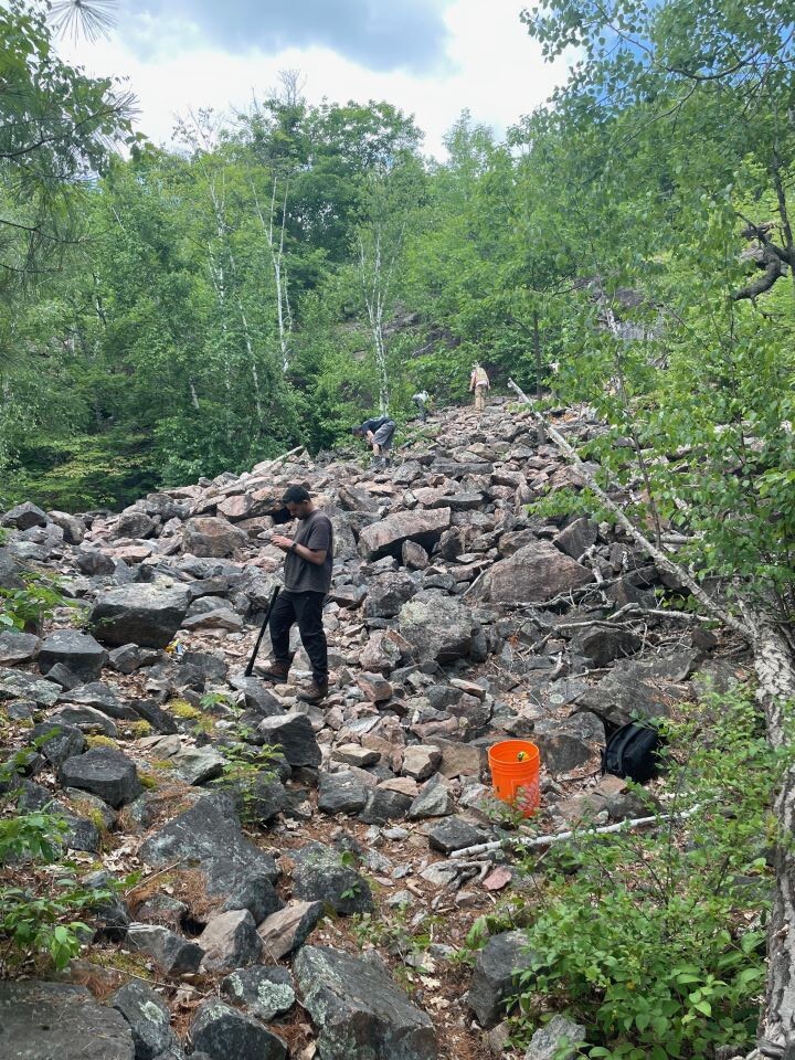
There was a final flurry of activity at the pits in lot 11 in 2005 when a mixed Queen’s University – Royal Ontario Museum team excavated all of the broken calcite in both pits and screened it, leaving a massive screen-dump in the north west corner of the first pit. Unfortunately, this earth-dump lies directly over the location where the best spinel crystals were found in the 1970s in the underlying calcite by George Robinson (pers. comm., 2019). After that work the pits lay forgotten and apparently unvisited until the summer of 2018. There was an even and undisturbed blanket of moss, almost four inches thick in places, over the floor of the entire first pit when it was next visited by Doug Scott, John Montgomery and Dave Maclean. It was also stated at that time by Mr. A. Morrison, the property owner, that he knew of no visitors since the Queen’s-ROM team “about 15 years ago”. Of the two pits, only the first one (nearest the Menzies Munro sideroad) is presently accessible for collecting. The second pit has been used as a repository for brush, dead branches and stumps by the farmer who rents the use of the adjacent fields and is currently filled to a depth of some five feet with a jumbled mass of rotting wood.
Please note that the pits are on private property and that the adjacent field is being actively farmed so random visitors without permission are strongly discouraged. Field trips to the site have been organized by the OVMC with the permission of the owner and these are expected to continue in future years.

The Minerals to be Found in the Spinel Pit on Lot 11
Spinel
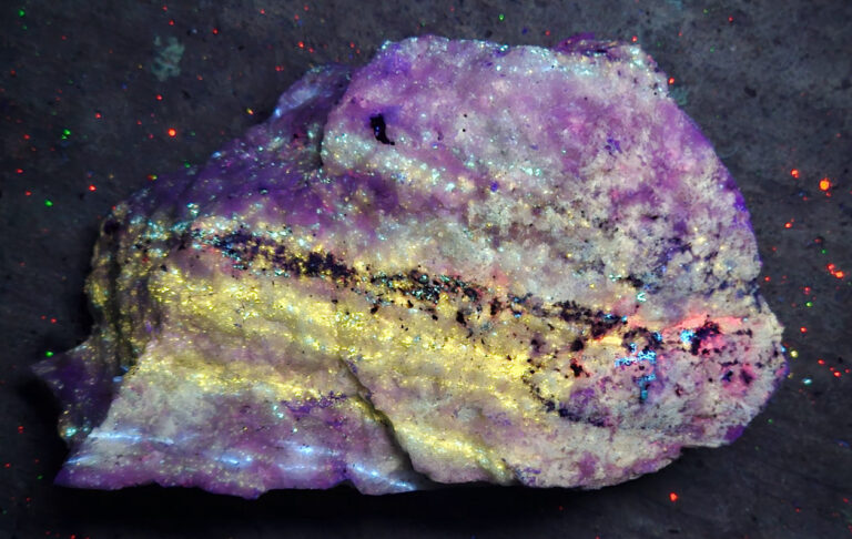
The spinel crystals from both lots are of an unusual form in that they are composed of an ascending hierarchy of increasingly sized octahedrons in parallel growth, beginning at about 1 mm and then grouping to form ≈5 mm composite-octahedra. These sub-octahedra then grow together at their corners to form larger composite-crystals to a maximum of about 5 cm. The spaces between the sub-octahedra may or may not be filled, partially to completely, by 1 to 2 mm octahedra in parallel growth. The fact that all of the tiny octahedra are in crystallographic continuity is seen by the simultaneous reflection of light from a “large” octahedral face by a multitude of tiny triangular faces. It is rare but observed that isolated octahedra greater than 5 mm in size show a smooth uninterrupted octahedral face with faint triangular markings only. Collecting note: if you have a black crystal and see the tiny triangles then it is a spinel (no matter what it looks like) but if you see nothing or oval shapes from a smooth face then it is a hornblende, unless that face is a large triangle itself.
The preceding description of the spinel implies that it always forms regular octahedral crystals. That is correct only at the smaller sizes (up to ≈5 mm); larger composite-masses of small octahedra are frequently severely distorted and appear to have grown by displacement preferentially along cleavage planes in the host calcite, forming highly irregular and cavernous masses. In terms of overall numbers, these distorted masses of spinel are much more common than are regular octahedral crystals. Also, late tectonic movement has broken some of these spinel crystal-masses, both via mechanical-fracturing and along the crystal body-diagonal parting, forming numerous small fragments of spinel which are now randomly dispersed in the calcite.
Hogbomite
In 1983 the mineralogical interest in the locality switched abruptly from the spinel and its pseudomorphs to the very rare mineral högbomite (Wight, 1986). In May 1983 Quintin Wight (now an OVMC member), showed Dr. Richard Herd from the Geological Survey of Canada what Quintin assumed was a sharp, shiny, black biotite crystal on spinel. Dr. Herd pointed out on the “biotite” similarities to a Swedish högbomite. Later Dr. R.I. Gait from the Royal Ontario Museum found similar black crystals in their material from the locality and analyzed them, confirming Dr. Herd’s guess. It was the first reported occurrence of a högbomite-group mineral in Canada. However, in the brief description of this occurrence in Rocks and Minerals magazine the locality was again given only vaguely as “seven miles southwest of the town of Perth” (King, 1986).
There is one additional note on högbomite from this locality by Quintin (Wight, 2003), with the first published photographs of crystals but no analyses. Quintin did however get specimens analysed by X-ray diffraction at the Canadian Museum of Nature. Ralph Rowe, the X-ray technician, reported that the material was an almost exact match with the powder data for the polytype magnesiohögbomite-2N3S. A suite of eleven samples which showed the högbomite crystals in various orientations on the spinel crystals was sent to Dr. Don Doell in 2019; he analysed them by Raman spectroscopy at Arizona State University and proved that all of them were magnesiohögbomite (polytype undefined). The possibility that some of the rod-like crystals were rutile or another variety of högbomite was discredited; they are merely different views of flat plates that are partly overgrown by spinel.
One of Quintin’s photographs (Wight, 2003, Figure 3, page 180) is particularly significant since it clearly shows that the högbomite crystal grew on the octahedral face of an unaltered spinel crystal and the crystal was later replaced by corundum. The corundum replacement of the spinel is therefore very late in the paragenetic sequence and took place at some time after the influx of titanium-bearing solutions that deposited the högbomite. One 10 mm wide composite spinel octahedron was observed that had been broken along the body-diagonal parting and showed two högbomite crystals growing on the parting surface, and another specimen showed six crystals, so their deposition appears to either post-date the major fracturing episode or be coincident with it.
The magnesiohögbomite occurs as translucent to transparent pale brown euhedral crystal plates, the majority showing a flat pinacoid face with sharply defined hexagonal-prism edges (usually more or less badly physically chipped). There is a perfect {0001} cleavage parallel to the pinacoid and, with chipping, this can produce the appearance of a stepped crystal or of one crystal perched on top of another. Almost all of these crystals were deposited on the surface of the spinel crystals; the majority of them are located flat on the spinel octahedral faces and appear to be epitaxial overgrowths. They are not however restricted to this orientation and are frequently found “edge-on” with a prism face against the spinel or even (rarely) bridging the gap between spinel sub-crystals. In one case a cluster of three crystals was found that surrounded the triangular gap between three adjacent 5 mm spinel crystals and exactly counterfeited the appearance of a cyclic twin of rutile.
The first published use of the term “pleonaste” for the spinel crystals from the DeWitts Corners locality appears to have been in the Ferrier and Graham (1928) paper and to have been based on three observations: that the spinel was iron-bearing, was non-magnetic, and showed occasional dodecahedral modification of some of the octahedral faces. No analysis of the spinel was published before the microprobe analysis of George Robinson (Robinson and Chamberlain, 1982) which yielded the formula: (Fe0.35Mg0.65)Al2O4 and confirmed that Mg>Fe in the crystals and that the mineral is a ferroan spinel. George repeated the pleonaste designation in that paper but confined its meaning to the chemistry of the crystals; he did not however repeat it in the more recent book “Minerals of the Grenville Province”, Robinson, G.W., Chiarenzelli, J., and Bainbridge, M., (2019) and its future use by the mineral-collecting community is not encouraged.
Spinel Alteration
Tiny magnetite, as rounded octahedra, mainly less than 3 mm in size, are also present on some of the larger spinel crystal-groups but are rare and are usually severely surface-altered to orange goethite. The spinel crystals themselves have experienced two very different forms of alteration. The less common type at this locality is to a mica and it varies from a weak surface coating of mica plates to essentially complete replacement of the spinel by phlogopite. Such alterations are not uncommon on a world scale (Palache et al., 1955, Vol. 1, page 695); however, the other form of alteration of this spinel appears to be almost unique to this local area of Bathurst Township. This unusual alteration takes place pseudomorphically and converts the spinel into a granular mixture of pale grey-green opaque corundum and calcite (Ferrier and Graham, 1928). George Robinson (Robinson and Chamberlain, 1982) also commented on this: “Perhaps one of the most interesting features [at this locality] is the frequent presence of corundum overgrowths, and complete pseudomorphs of corundum after spinel have been found.”
Translucent Corundum
Colourless to very pale yellow or green translucent crystals of corundum, displaying fragments of the common squat barrel-shape, to about 10 mm in maximum size, have been rarely observed either free in the calcite or surrounded by, but not intergrown with, the cavernous masses of spinel. These crystals frequently show a strong basal parting; this appears in hand-specimen to be a slightly interrupted cleavage-plane with a weak pearly lustre which caps the ends of the crystals. These crystals are quite different from the pale grey-green opaque and somewhat granular appearing corundum that surface-alters the larger spinels and rarely completely pseudomorphically replaces the smaller spinel crystals. The best and most complete pseudomorphs observed in recent collecting are all in the 5 mm size range; however, there is at least one pale green 15 mm complete pseudomorph in the National Museum collection.
Hornblende and Diopside
Two other hand-specimen sized minerals observed in recent collecting are copious amounts of hornblende, in sharp shiny-black tabular euhedral crystals to 2 cm, and large numbers of ≈5 mm dark green diopside crystals that all show the typical pyroxene-crystal square cross-section. Since almost all of these specimens were obtained by reworking the screen-dump, no exact locations within the calcite vein-dike are known but, from the few bits of original outcrop observed, it seems that the masses of mixed hornblende and diopside crystals in white calcite occurred on or near the walls of the dike whereas the spinel crystals in salmon-colour calcite occupied the central portions of the western end of the dike. The grey-white calcite in the centre of the pit seems to be rich in isolated hornblende and pyroxene crystals, with associated fine dolomite, but poor in spinel. It is worth noting that Hunt (1848) describes black tourmaline as occurring in the “rocks” (calcite or wallrock was not specified) but tourmaline has not been observed in any recently collected specimens.
Other Minerals
Some of the spinel crystals, surprisingly not those partly altered to corundum but rather the cavernous and distorted crystals, are locally thinly coated with a pale fawn-coloured layer of böhmite [AlO(OH)]. This layer can be flaked from the spinel crystal-face and does not appear to be an alteration product of the underlying spinel but rather to be something that precipitated onto the crystal.
Other minerals observed in small quantities in the screen-dump include fragments of bright glassy yellow-green crystals of scapolite. Their unusual aspect is that this scapolite is an almost perfect intermediate species, microprobe analyses show a range of meionite to marialite between 49 and 51%. Tremolite has also been observed as small yellow crystals in calcite and clinochlore as masses of rather coarse dark green crystal plates to 5 mm. in size. The grey-white calcite from the central area of the pit does not completely dissolve in acid but leaves a granular residue of dolomite.
Postscript
A new variety of the högbomite-group minerals at DeWitts Corners was discovered in recent years by a team headed by mineralogists at the Canadian Museum of Nature. This new mineral is named magnesiohögbomite-6N12S and is visually indistinguishable from the previously known magnesiohögbomite-2N3S.
References
Dugas, J., (1961) Map 1089A, Geology Perth, Lanark and Leeds Counties, Ontario. Geological Survey of Canada.
Ferrier, W.F., and Graham, R.P.D., (1928) Pseudomorphs of Corundum after Spinel from Bathurst township, Lanark county, Ontario; with a note on the identification of the original locality of the spinel. Transactions of the Royal Society of Canada, Section IV, 1928, pp. 31-38.
Horváth, L., (2003) Mineral Species Discovered in Canada and Species Named After Canadians, The Canadian Mineralogist, Special Publication 6, p. 289.
Hunt, T.S. (1848) Annual Report of the Geological Survey of Canada 1847-1848, pp. 133-134.
Joyce, D.K., (2006) Calcite Vein-Dikes of the Grenville Geological Province, Rocks & Minerals, Vol. 81, #1, pp. 34-42.
King, V.T. (1986) World news on mineral occurrences. Rocks and Minerals, Vol. 61, #6, pp. 345-349.
Logan, W.E., (1863) Geological Survey of Canada Report of Progress from its Commencement to 1863, 983 pp.
Lykova, I., Rowe, R., Poirier, G., Giester, G., and Helwig, K., (2021). Magnesiohögbomite-6N12S, Mg5Al11TiO23(OH), a new högbomite-group mineral from the DeWitts Corners, Ontario, Canada. Mineralogical Magazine, Vol. 85, pp. 398-405.
Palache, C., Berman, H., and Frondel, C., (1955) The System of Mineralogy, Seventh Edition. Volume I, page 695.
Robinson, G., and Chamberlain, S.C., (1982) An Introduction to the Mineralogy of Ontario’s Grenville Province, The Mineralogical Record, Vol. 13, No. 2, pp. 71-86.
Robinson, G.W., Chiarenzelli, J., and Bainbridge, M., (2019) Minerals of the Grenville Province New York, Ontario and Quebec, Schiffer Publishing, 207 pp.
Traill, R.J., (1983) Catalogue of Canadian Minerals, revised 1980, Geological Survey of Canada paper 80-18, page 346.
Wight, Q., (1986) Hogbomite. Excerpted from Mineral Mite, April 1984, in King, V.T. (1986) Rocks and Minerals, Vol. 61, #6, p. 346.
Wight, Q., (2003) What’s New in Minerals. The Mineralogical Record, Vol. 34, No. 2, pp. 180-182.


You really covered all the ground here Doug. Congratulations!